Tuesday 10 October 2023

Groovy Kinder Love Entry and runners’ information

Enter Online

Groovy & Baby Kinder Love

I have added the option of running a shorter version of the Groovy Kinder Love with a totally uninspired name "Groovy Baby Love". Its details are below. As a BM it is still a challanging route. Both races start together and follow the main race route to the Broad Clough CP and splits at the Broad Clough ford. The "baby" crosses the ford and goes over the stile while the main race turns right to follow the Broad Clough for 30(ish) metres before crossing and going through a gate to climb back up to the three knolls path. The baby continues around to briefly meet the main route again at Benny's bridge/bottom of Sandy Heys CP, where the baby turns left to climb up to the Shooting Cabin CP while the main race climbs up William Clough. Both routes then meet again for the final descent from the Shooting Cabin CP to the finish.

I will just have a single entry for both races (so you just enter the Groovy Kinder Love). You can decide at race number allocation which route you want to run. My race limit of 200 then covers both races so I will not have 400 running. 

The Groovy race numbers will start at 1, while the baby will start at 150.

RACE DETAILS - Groovy Kinder Love

  • Date & time: Sat 14 Sep 2024 at 11:00
  • Start time info: Valley Road Electrical Substation
  • Country: England
  • Region: Peak District
  • Category: AL
  • Website: http://pennineridgefellrunner.blogspot.com
  • Distance: 24.5 km / 15.2 miles
  • Climb: 1290 m / 4232 ft
  • Venue: Scout Hut, Swallow House Lane, Hayfield., SK22 2HB
  • Grid reference: 034871
  • Skills: ER, LK, NS
  • Minimum age: 18

RACE DETAILS - Groovy Baby Love

  • Date & time: Sat 14 Sep 2024 at 11:00
  • Start time info: Valley Road Electrical Substation
  • Country: England
  • Region: Peak District
  • Category: BM
  • Website: http://pennineridgefellrunner.blogspot.com
  • Distance: 18 km / 11 miles
  • Climb: 920 m / 3020 ft
  • Venue: Scout Hut, Swallow House Lane, Hayfield., SK22 2HB
  • Grid reference: 034871
  • Skills: ER, LK, NS
  • Minimum age: 18

ENTRY INFORMATION

  • Entry on day: Yes
  • Entry on day fee: £12.00
  • Pre-entry: Yes
  • Pre-entry fee: £10.00

https://pennineridgefellrunner.blogspot.com/2017/09/groovy-kinder-love-online-entry.html

CONTACT FOR RACE INFORMATION

  • Patrick Barry
  • 07770149757
  • GroovyKinderLove@penninefellrunners.co.uk
  • Race Organiser: Patrick Barry


Groovy Kinder Love 2023

PENNINE FELL RUNNERS

Groovy Kinder Love runners’ information

Back for the fourth (and my third year)  running of the event. Thank you to you for entering the event. We hope you have a good ‘un.
Please read the below info thoroughly...

Start:
Age limit:
Records:

Saturday 16 Sept at 11.00 am
18
Male 2021 02:14:40
Female 2021 02:51:03

Kit Check 

There will be 100% Kit Check.

You will have to sign the FRA Consent on the Senior Entry Form (Fabian entry covers this requirment). Pens and forms will be available on the tables in the Scout Hut.  All personal data will be destroyed once the race is over.
If anybody is stuck, I have a handful of whistles and compasses that I can sell at cost price (£1 and £4). I have also printed off 12 race maps that are in an A4 plastic sleeve. If anybody wants to buy a map on race day for £1 just let me know, I can easily print off some more based on demand.

There will be a table inside the Scout Hut where we will take the consent form and give you your number. Safety pins are in the scout hut.

Race entry details are above the limit is 200 runners.

Entries are currently open.

Registration

·         Registration CLOSES at 10.20 am.

·         Registration is at Hayfield Scout Hut on Swallow House Lane

·         (GR035873), approximately 10 min walk from the start.

·         Please park with due consideration to residents. Competitors should try to lift – share and use the main village car park adjacent to The Sett Valley Trail. Limited parking will be available on hard surface adjacent to the Scout Hut, please don’t park on the grass. Please don’t leave your cars there after the race as we need to lock the gates.

·         As always cars are parked at owners’ risk and no liability can be accepted for theft or damage.

·         Please allow plenty of time for registration.

Route

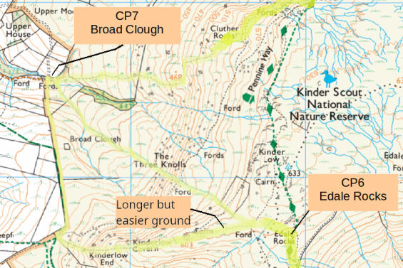
See the route descriptions at: Race Details and take note of the three hour-thirty cut-off at the bottom of Sandy Heys (take note this is a change from the previous cut-off at Broad Clough). I would expect the back markers to be no more than 75 minutes to complete the route from here meaning that everybody will be home in Four hours-Forty-Five minutes. I am happy for anybody timed out at Sandy Heys to continue straight up to the Shoot Cabin to rejoin the race route for the final descent, which means they will only miss the William Clough climb.

General Comments:

·         Start Finish – please find the details here: https://pennineridgefellrunner.blogspot.com/2021/07/groovy-kinder-love-startfinish.html The last section is through the village centre, so be careful crossing the main street.

·         Much of Kinder is part of one of the 54 Sites of Special Scientific Interest (SSSIs) in the Peak District National Park, which has considerable effect on events that can be held in these areas. Keeping the event on Public Rights of Way(PRoW) within an SSSI’s, considerably eases the process of gaining permission from Natural England (NE).  For this reason this event does have limited route choice with the main “off-piste” section being the difficult section from Edale Rocks, through The Three Knolls to the ford on Broad Cough and then back up to Cluther Rocks. The descent here is particularly difficult without any “trods” though the thick heather and rocks. It may be best to try to follow one of the stream beds down as shown on the map.

·         Jacobs Ladder, is a very busy walkers route so as a safety measure runners will be directed through the gate to follow the mountain bike track to the bottom of Jacobs Ladder.

·         The Checkpoint at the top of Jacobs Ladder path is only active for runners descending.

·         The Edale Rocks checkpoint is on the South Side beneath the over-hang

·         All field boundaries, on this path must be crossed using stiles. Please do not climb gates or jump walls (the local landowners do look out for this). I have agreed that if people are not using stiles, or damage stiles; this will result in disqualification. Our permission to continue to run the event depends on the goodwill of local landowners.

·         This is a Category AL race. The route does traverse high mountain terrain and weather conditions at this time of year may be hostile. Weather is often unpredictable. Competitors should have experience of this type of event and it is not suitable for novices. The route is a combination of marked and unmarked paths. Navigational skills are required, especially in mist, and prior knowledge an advantage - it’s all open to recceing in advance. The kit list is mandatory and if you don’t have the correct kit (including map and compass) please don’t try to take part.

·         If conditions are difficult on the day and/or you don’t feel comfortable or confident in being able to be safe – don’t take part. If it’s called off we will review whether we will carry entries over to next year. We won’t run a bad weather alternative route.

·         Remember to be respectful of other people out on the hill and to look after one another. There will be other people out on Kinder so say hello if you can manage it.

Equipment

Competitors MUST carry at least all of the following equipment regardless of the weather on the day:

a)            Waterproof whole-body cover with taped seams, hat and gloves

b)            Compass and map suitable for navigating the course

c)            Whistle

d)            Emergency food

The route will also be on show on the wall of the scout hut at registration if people want to mark their own maps up.

This is a fell race and the course is not flagged for the majority of the race. YOU ARE RESPONSIBLE FOR YOUR OWN NAVIGATION AROUND THE COURSE. You need to provide your own map (and compass) and be able to navigate by it on your own even in bad visibility or bad weather.

Monitoring of competitors

At registration, you will be allocated a number which will be recorded out on the course, so please ensure it is clearly visible on your chest.

IMPORTANT!!!

If you retire at any point, after collecting your number and wristband, you must inform the race organizer and hand in your number at THE FINISH FUNNEL – YOURSELF, IN PERSON. This still applies even if you’ve told someone out on the hill or a marshal out on the course.

If this is not done the mountain rescue (MRT) may have to initiate a missing person search. Do not drop out and tell someone else, thinking they will inform race control or take your number back for you. This has happened before and MRT were out looking for someone who was in their friends’ car on the way home!

Checkpoints!

Race numbers must be clearly displayed at the ford at the bottom of Broad Clough. There is a two hour cut off at Broad Clough. Anybody arriving after that time will be required to head directly back to the finish.

Be respectful to the Marshals and Mountain Rescue Teams who are volunteering to support

your safety on the hill.

Prizes

We have prize categories for 1st to 3th Man and Woman, and M/W’s categories of Under 23, V40, and upwards in 10yr increments. Good luck.

Prize giving will probably be around 3pm in the Scout hut.

...and lastly, have a good run!

Patrick Barry - Pennine Fell Runners.

Email GroovyKinderLove@PennineFellRunners.co.uk

Wednesday 20 September 2023

Instructions for setting up a Spunch event

Create a Spunch Course

One of the women in Pennine put together a Spunch event, which proved very popular. I spoke to her about it afterwards and she was telling me the most difficult thing was correctly identifying the checkpoint positions. Below shows the difficulty. Say you want to put a checkpoint by the little island in the river south of the "S" of Mermaid's Pool below Kinder Downfall.

This is what you have to work with. If you have something distinctive like a path/wall/river junction, etc it is no problem finding your checkpoint otherwise you have a challenge.

Above are the instructions that we were provided with to enable us to produce a course - The section requiring the use of Google Earth to precisely fix the checkpoints is not easy.
My profession is in software development. Back during the first lockdown I had a go at writing an Android MapRun type of app using Java. I did not get very far on it but I got the basics of establishing my position going. From a OS map it is very easy to get the Eastings and Northings for the desired position, you just need to convert that into  Longitude and Latitude. There are rather scary maths involved but it is possible to convert between the two systems. After chatting about the issues highlighted above I did a bit of Googling and it turns out it is actually very easy to get a Longitude and Latitude from a OS map using Bing maps. 

Below I am just expanding the instructions in the attached PDF and adding my own alternative for getting accurate CP locations.

1)    https://oomap.co.uk/ then click on Version 4
2)     Select PseudO

3) Click A4 and 40K
This is now the area that will be printed on an A4 sheet.


4) Click on the map at the desired start point to display this menu
The first checkpoint must be the start and then progress though all the CPs until selecting finish as the last one. Ensure that the finish position is selected so that the competitors do not accidently pass through it  while waiting to start or while out on the course. Use whatever features are available on the map to correctly position  your checkpoint. If that is not possible just position it vaguely in the correct position.

5)    Once you have selected all the CPS then progressively start to click down through these map sizes to get the smallest one that will contain all of your CPS. The blue dot can be used to move the map frame around.


6) Click on KML to download the list of checkpoints.


Click on KMZ to download the actual map
If desired click on the PDF map button to download the graphic of the course.

7) Now we need to fix any suspect checkpoints
Checkpoint 7 is intended to be at the wall corner directly south of the "D" of District. But it was pure guess work when positioning it.

Use a text editor to edit the "kml" file that was downloaded. The simple notepad that is in Windows would do; but a much nicer one is Notepad++ which can be downloaded for free from here. Notepad++
The KML file will look something like below. 
In my case I want to fix the highlighted number for CP7
It is as simple as go to Bing Maps zoom into the area and switch to OS view

Zoom right in to just before the OS view disappears and right click on your desired CP to view its longitude/latitude at the bottom of the popup.
Now you just need to replace the longitude/latitude values in the KMZ file with those you got from Bing. Be careful you do not loose the zero at the end.
The Bing values are less accurate. However with six decimal places they still go to 1/1,000,000 of a degree, which is still more than accurate enough for a Spunch event. What would be nice is the ability to re-upload the KMZ file to the website so that your CPs will be "fixed" on that as well but it is not possible.

The chart below provides more details on the level of accuracy provided based on the number of decimal places in the coordinates:

Decimal PlacesDegreesDistance
01.0111 km
10.111.1 km
20.011.11 km
30.001111 m
40.000111.1 m
50.000011.11 m
60.000001111 mm
70.000000111.1 mm
80.000000011.11 mm

8) Without a MapRun account it is still possible to upload your course for testing purposes using this site: CheckSites


Fill in the details and Click "Add the Event" to receive back a unique code for that event


On MapRun on your mobile phone click the menu in the top-right corner (on Android - iPhone may be different) and select CheckSites. Input the number from above and you are good to go to test your route.

I created a test route in the hills behind my house with 33 CPs. All of them I "fixed" using the method outlined above and went for a run. It got every one. The only problem was the app stopped a number of times.  I went though locations I knew should have "beeped" and it did not. On checking the phone the  app had stopped, I clicked resume and went back to the CP and it "beeped". I am guessing a power saver mode was stopping the GPS while using the app in CheckSites mode - need to look into that.

After the activity the CheckSites mode allows you to analyse the accuracy of the CPs. Even down to 2m accuracy it would have still got all of them.

You now require a MapRun account to upload it, which I do not have. The attached PDF has the detailed instructions, and recommended best practices, for this stage of the process.

An Ordnance Survey account  can then be used to produce the competitor OS maps and there are many image editors available that will allow you to draw the CP locations such as the two examples below to supply to the competitors.